


Mappt
GIS Data Collection
Description of Mappt: GIS Data Collection
Mappt is a GIS (Geographic Information System) data collection application designed for users to create, edit, store, and share location-based data efficiently. This app is particularly beneficial for those involved in various industries, including environmental management, agriculture, mining, and local government. Available for the Android platform, users can download Mappt to access its extensive features aimed at simplifying field data collection.
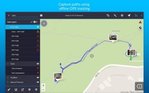
The application provides a user-friendly interface that allows both new and experienced users to navigate its functionalities with ease. A standout feature of Mappt is its ability to operate offline, enabling GPS tracking without the need for internet connectivity. This is particularly useful for field workers who may find themselves in areas with limited or no network access.
Mappt supports the import and export of popular GIS formats such as Shapefiles, JP2, and KML/KMZ, which ensures compatibility with widely used desktop GIS software like ArcGIS and QGIS. Users can also read and download a wide range of datasets, including WMS, WFS, and WMTS, allowing them to enrich their data collection efforts with relevant geographic information.
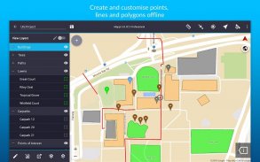
The app includes functionalities for field mapping, land surveying, and vegetation management. Users can manage forestry planning and environmental assessments effectively with the tools provided. Utility mapping and asset management are made easier through the comprehensive features available within the app. The ability to conduct incident reporting and mine management tasks directly from the field enhances the app's utility for various professional environments.
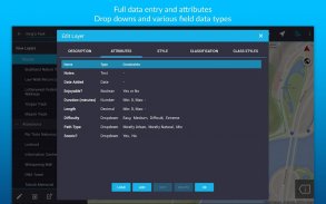
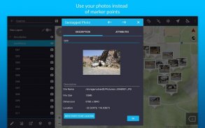
Mappt’s geotagged photos feature enables users to add a visual element to their data collection. By attaching images to location points, users can provide context and clarity to their datasets. The app also incorporates drop-down forms, which streamline data entry processes and enhance efficiency during fieldwork.
On-screen annotation tools are available for users to draw, add text, and create shapes over their data. This feature facilitates precise documentation of observations and findings during field surveys. The inclusion of coordinate grids allows users to visualize distances between areas, aiding in more accurate analyses and assessments.
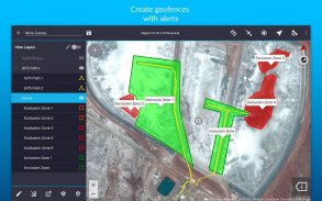
Geofencing capabilities ensure that users remain within designated boundaries while collecting data. This feature is particularly useful for projects requiring adherence to specific geographic restrictions or regulations. The app also offers a street view mode, providing users with the ability to view and annotate locations in a familiar visual context.
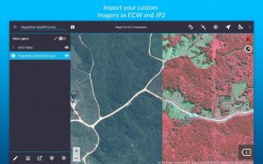
Mappt allows for the importation of various types of imagery, including satellite, aerial, geological, and topographic images in ECW and JP2 formats. This flexibility in data types enhances the depth of analysis and aids in comprehensive project planning. Users can also share their collected data seamlessly through popular cloud storage solutions, such as Google Drive, making collaboration and data accessibility straightforward.
The app's offline capabilities mean that users can focus on their data collection efforts without worrying about internet connectivity. This aspect of Mappt ensures that field data remains accurate and reliable, regardless of the environment. With its suite of tools and features, Mappt addresses the needs of professionals who require efficient and effective methods for gathering geographic data.
Trial users can experience Mappt for 120 minutes, providing an opportunity to explore its functionalities before making a decision. After the trial period, users have the option to wait for an additional 120 minutes after an 8-hour period or to purchase a monthly license starting at US$29. This licensing model offers flexibility for users based on their engagement level with the app.
The combination of easy-to-use features, offline functionality, and integration with existing GIS systems makes Mappt a practical choice for a wide range of industries. Whether for agriculture, environmental management, or local government initiatives, the app provides essential tools that facilitate effective data collection and analysis.
Incorporating these features, Mappt stands out as a versatile GIS data collection application that adapts to the needs of users across various sectors. With its commitment to enhancing data accuracy and efficiency, Mappt provides a reliable solution for professionals working in the field.
For more information about features and licensing tiers, please visit www.mappt.com.au/pricing.
Mappt: GIS Data Collection - Version 3.14.2
(01-03-2025)Mappt: GIS Data Collection - APK Information
APK Version: 3.14.2Package: au.com.mapptLatest Version of Mappt: GIS Data Collection
Other versions


Apps in the same category

You may also like...


